

Leica Measuring Tools
 The advantage of this tool is obvious: What had to be measured earlier by the surveyor can now be done as a whole package by you. Take a full survey of the lot and existing foundation for example. Then to be able to take your points and shoot them back on site during the construction process to find locations for rebar, sills, or locating important members of the project precisely, and many more. Builders or engineers can now generate this data so the value is added to the entire project; it's an extra service you can offer.
- Topographic data implementations
- Production data (building on a slope)
- Placing hardware on beams
- Drilling placements/angles and depths
- Integration Landscape
- Volume of fill / excavation
So what can this tool do for me?
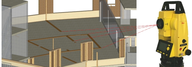
It's not just a survey station! Some of the key functions to this machine is the measure and lay out functionalities. Whether it's an interior room, a site survey, or a facade, no matter what you are measuring, everything can be measured together as a whole inside one project. Once you have everything measured out on site the data is directly transferred to cadwork where the points are connected with lines. No more going back and trying to decrypt hundreds of nodes after a big survey.
The total station is easy to handle and the connection to cadwork is simple. All functions are described in a compact handbook clearly understood; cadwork also supplies you with a tutorial to quickly get started. Any questions will be answered promptly by our reliable and quality support team.
The data you shoot is immediately visualized.
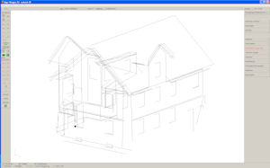
This is where measurement errors for the most part can be avoided, you see the result of your measurement instantly on the screen of PC proving your point are correct. While importing your points as you add them you also have the option to draw while you shoot nodes and better represent elements in the project with surfaces, lines, and even assign names.
At 100 feet, an accuracy of 1/16” is reached with this station.
There are no data packets (point clouds) cached somewhere, but from the total station transferred to CAD. This is an important distinction, because the directness guarantees the dominance of the measurements, because as mentioned above the measurements are immediately visible.
Also when laying out hundreds of points with the device it is easy to pack up and come back the next day, you set a reference point in your project on the device and every time you set up again, the station can help you get positioned and back on track with shooting points.
This system guarantees even highly complex structures with many curves and different levels of elevation an error-free installation. No element can be forgotten because it's in complete 3D on your PC.
Quicklinks:
Documents: